Explore the communities and search
for the best Real Estate Values
Minden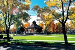 Downtown Minden City Park
Minden Established in 1905 as county seat Minden, the county seat for Douglas County, is at the base of the Sierra Nevada range and has an elevation of 4,700 feet above sea level. Life in Minden offers the conveniences of small town living with all of the facilities of Lake Tahoe (20-25 minute drive) or Reno (45-50 minute drive) within easy reach.
Minden is named after a small town in Germany - "Minden, Germany". The towns of Minden, Gardnerville, and Genoa make up the "Carson Valley" which offers great mountain views, four seasons, and plenty of sunshine. As of the census of 2000, there were 2,836 people, 1,166 households, and 839 families residing in the CDP. The population density was 664.2 people per square mile (256.4/km²). There were 1,231 housing units at an average density of 288.3/sq mi (111.3/km²). The racial makeup of the CDP was 94.04% White, 0.07% African American, 0.71% Native American, 1.13% Asian, 0.11% Pacific Islander, 2.08% from other races, and 1.87% from two or more races. Hispanic or Latino of any race were 6.59% of the population. There were 1,166 households out of which 28.1% had children under the age of 18 living with them, 62.4% were married couples living together, 7.7% had a female householder with no husband present, and 28.0% were non-families. 23.0% of all households were made up of individuals and 11.5% had someone living alone who was 65 years of age or older. The average household size was 2.38 and the average family size was 2.78. In the CDP the population was spread out with 21.9% under the age of 18, 4.4% from 18 to 24, 22.7% from 25 to 44, 27.5% from 45 to 64, and 23.5% who were 65 years of age or older. The median age was 46 years. For every 100 females there were 95.5 males. For every 100 females age 18 and over, there were 92.4 males. Gardnerville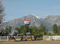 Rural Settiing in Gardnerville Nevada
Population: 4,983 • Elevation: 4,750 The Town of Gardnerville was founded in 1879 by Lawrence Gilman of Genoa when he moved the Kent House from the Genoa area to a 7-acre tract of land on the East Fork of the Carson River. Gilman had purchased the land from a homesteader, John M. Gardner, in whose honor he named the new town.
Today, Gardnerville is a thriving community in the heart of the beautiful Carson Valley. Its location is ideal for both the nature lover and the more suburban at heart: The splendor of Lake Tahoe is just a short drive to the west and Reno is less than an hour north. Gardnerville's weather is pleasant throughout its distinctly different four seasons. Warm summer days with cool nights are balanced by the crisp chill of winter with an occasional light snowfall. Spring and fall provide tastes of each in perfect transition. Northern Nevada has a healthy economy and the Carson Valley is no exception. Housing is plentiful and there are various communities within the area for all income levels. Carson City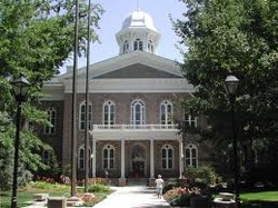 State Capitol Building Carson
City Nevada
Carson City is approximately 153 square miles in area. It abuts the Sierra Nevada Mountains which are the entrance to the basin from the west and the terminus from the east. The magnificent mountains intercept and exhaust the moisture of the air currents ever flowing from the Pacific Ocean eastward, consequently they pass comparatively rainless over the broad basin region, leaving it desert-like.
Population as of 2000 census 52,457 Land Area in square miles 146 Land Area in square kilometers 371.8 Elevation 4,687' above sea level Position 39.14 degrees north of the equator and 119.74 degrees west of the prime meridian South Lake Tahoe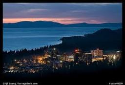
The City of South Lake Tahoe is part of a broader South Shore community that includes California's El Dorado County in the Tahoe Basin and Nevada's Douglas County at Stateline & Zephyr Cove. In this section, you'll find facts, historical summaries and direct links to other informational sites related to "Our Town."
Topaz and Surrounding Communities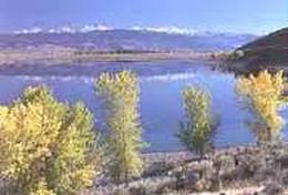 Topaz Lake Nevada
Topaz Lake is a reservoir located on the California-Nevada border, about 75 miles (121 km) south of Reno.
The lake was formed by diverting waters from the West Walker River into a nearby basin that had previously contained a smaller, natural lake. The initial construction took place in 1922, resulting in a reservoir with a capacity of 45,000 acre feet (56,000,000 m3). In 1937, a new levee raised the capacity to its current 59,440 acre feet (73,320,000 m3). Topaz Lake is popular for boaters, water-skiers, campers, and fishermen. Fishing season runs from January 1 to September 30, and the lake is stocked with trout by the Nevada Department of Wildlife and the California Department of Fish and Game. The lake is easily reachable by U.S. Route 395. On the northwest shore of the lake is the Topaz Lodge, and a residential area. There is also a volunteer fire station in the area. Route 395 passes by the west side of the lake at the California-Nevada state line. The southeastern terminus of California State Route 89 is 3 miles (4.8 km) south of the state line. The western terminus of Nevada State Route 208 is 2 miles (3.2 km) north of the state line. |
Find out More
Want more information about a living in the Carson Valley? Call Bill
OR Visit: visitcarsonvalley.org |
